Long-Distance Bike Trips (several days)
Quicklinks
Shorter Routes (40 - 90 km) - Longer Routes (90 - 150 km)
The following bike trips have been recoreded with a Garmin Edge 800 bike navigator. They are available as GPS tracks in *.gpx format which can be read by most GPS devices. You can also use the maps created with Google Maps on GPS Visualizer, a very confortable tool to create maps from GPS tracks in different formats. Most tracks are located in or around Berlin. Almost all the bike trips described here are suitable for trekking bikes. At least parts of them may however include unpaved roads and therefore might be somewhat difficult for racing bikes.
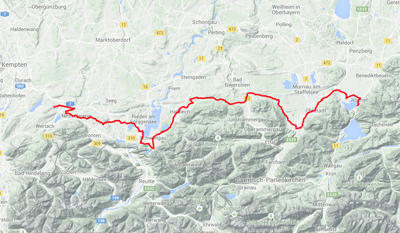
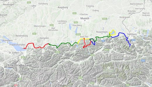
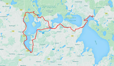
Bavarian Lakes along the Bodensee-Königssee Bike Route
The bike route starts in Lindau aus crosses southern Bavaria to Berchtesgaden thereby connecting quite a number of Bavarian lakes: Bodensee, Großer Alpsee, Rottachsee, Hopfensee, Kochelsee and Walchensee, Tegernsee, Schliersee, Chiemsee and Königssee. The GPS tracks are provided separately for different parts below to avoid the need to process too much data at a time. Be aware of the quite steep slopes along the route.overall distance:
647.4 km - overall uphill: 6489 m - overall downhill: 6358 m
|
|
|
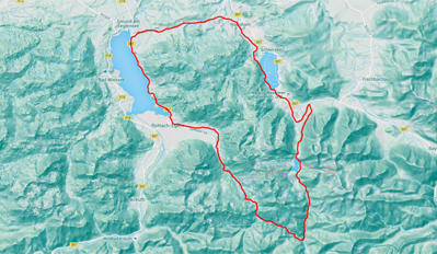
Part 1: Lindau - Oberstaufen - Großer Alpsee - Immenstadt - Oy-Mittelberg |
|
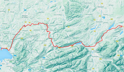 |
Trains from Munich run frequently to Lindau. This first part is the largest climb along the whole Bodensee-Königssee bike route with net about 600 m uphill. Beautiful landscape, well-paved and maintained paths. Distance: 98.2 km - Uphill: 1467 m - Downhill: 862 m. |
Part 2: Oy-Mittelberg - Hopfensee - Füssen - Schwangau - Kochel am See |
|
 |
Don't miss the old city of Füssen. You can also visit the palaces Hohenschwangau and Neuschwanstein along the route. Don't know whether it's worth it, though. Distance: 112 km - Uphill: 947 m - Downhill: 1340 m Download GPS track - open Google map - height profile |
Part 3: Kochelsee - Benediktbeuern - Bad Tölz - Gmund - Tegernsee |
|
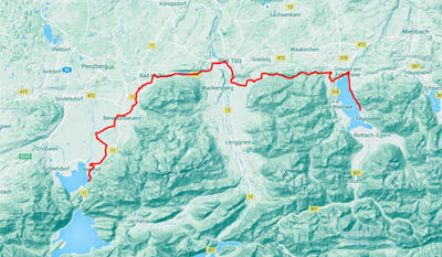 |
Shorter part for those who need a rest; can be combined in one daywith the Spizingsee tour, if not tired yet (see next). Seehotel Luitpold in Tegernsee is an excellent place to stay. Distance: 51.9 km - Uphill: 544 m - Downhill: 426 m Download GPS track - open Google map - height profile |
Excursion 1: Tegernsee - Spitzingsee - Schliersee - Gmund - Tegernsee |
|
 |
Very nice round course starting in Tegernsee. It does not belong to the official Bodensee.Königssee bike route and contains two very steep and long uphill sections. Once you have left the Tegernsee valley, you experience beutiful mountains along the "weiße Valepp" and the "rote Valepp". Distance: 50.0 km - Uphill: 794 m - Downhill: 794 m Download GPS track - open Google map - height profile |
Excursion 2: Tegernsee - Achenpass - Sylbensteinsee - Lengries - Bad Tölz |
|
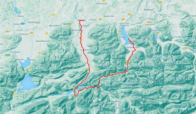 |
A second tour aside from the Bodensee-Königssee bike tour, which follows part of the "Via Bavarica Tyrolensis", a bike route that starts in Munich and goes along Tegernsee to Achenpass (border to Austria) and Achensee and then follows the Isar river back to Munich. You can return from Bad Tölz to Tegernsee either by train or by following the Bodensee-Königssee bike route as in Part 3. Distance: 64.9 km - Uphill: 559 m - Downhill: 616 m Download GPS track - open Google map - height profile |
Part 4: Tegernsee - Schliersee - Neubeuern - Aschau - Bernau - Prien |
|
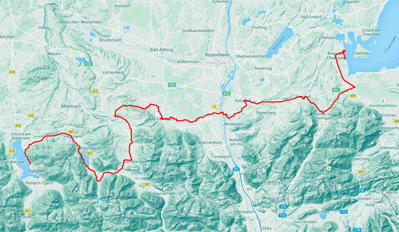 |
Fourth part of the Bodensee-Königssee bike route with a short detour on a paved street between Tegernsee and Hausham and an addition from Bernau to Prien at the Chiemsee. Distance: 92.5 km - Uphill: 805 m - Downhill: 1022 m Download GPS track - open Google map - height profile |
Excursion 3: Roundtrip around Chiemsee |
|
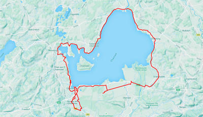 |
There are two official bike round trips around Chiemsee. This one follows (mostly) the one closer to the lake. Due to rainy wheather, there are a few small detours to cafes in Bernau. Herrenchiemsee island with its "Bavarian Versailles" palace can be visited by boat from Prien. Distance: 74.9 km - Uphill: 329 m - Downhill: 329 m Download GPS track - open Google map |
Part 5: Bernau - Traunstein - Bad Reichenhall - Berchtesgaden - Königssee |
|
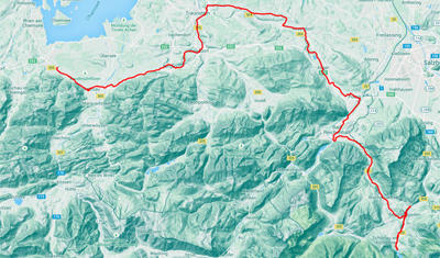 |
Last part of the Bodensee-Königssee bike route through an area which became rich in the past because of the salt produced here. Don't miss the Königssee with its almost vertical banks. Distance: 103 km - Uphill: 1018 m - Downhill: 969 m Download GPS track - open Google map - height profile |
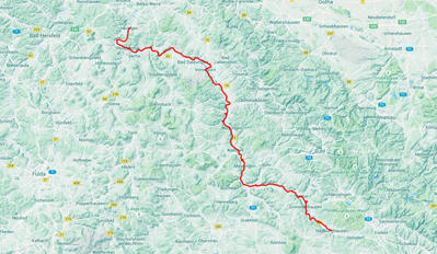
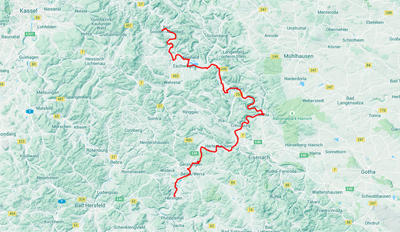
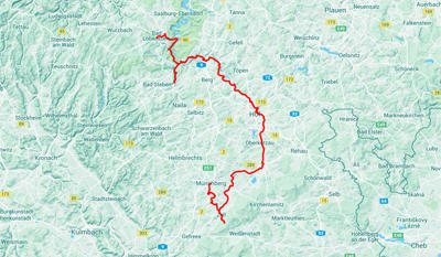
Rennsteig - Werratal - Leine - Harz
The bike route starts in Blankenstein at the Saale River and first follows the famous Rennsteig until the Werra springs are reached. From there it follows the Werratal bike route almost until its end, where it crosses to the Leine bike route leading to the south of Göttingen. The last part finally uses part of the Weser-Harz-Heide route from Göttingen to Wolfenbüttel. While the Rennsteig is certainly not suited for racing bikes, most of the Werratal route is well paved. Across the Harz, several non-paved passages exist.
overall distance: 551 km - overall uphill: 4220 m - overall downhill: 4510 m
|
|
|
Part 1: Blankenstein/Saale - Neuhaus am Rennweg - Hildburghausen/Werra |
|
 |
The first section comes with quite many steep slopes. Some fitness is required... Distance: 105 km - Uphill: 1429 m - Downhill: 1553 m. |
Part 2: Hildburghausen - Meiningen - Bad Salzungen - Heringen |
|
 |
Through the Werra valley, most of the bike route is rather flat. Have a look at the art nouveau Gradierwerk in Bad Salzungen, which has been used to produce salt and was then devoted to health and wellness purposes. Distance: 116 km - Uphill: 576 m - Downhill: 659 m Download GPS track - open Google map |
Part 3: Heringen - Gerstungen - Herleshausen - Treffurt - Eschwege - Bad Sooden-Allendorf |
|
 |
The route continues along the Werra river. In Bad Sooden, another salt mining facility is still in operation as a museum and you can learn about salt production throughout history. Distance: 106 km - Uphill: 417 m - Downhill: 440 m Download GPS track - open Google map |
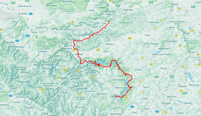
Part 4: Bad Sooden-Allendorf - Duderstadt - Herzberg - Osterode |
|
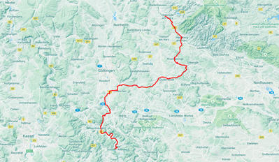 |
A short distance behind Bad Sooden, the route leaves the Werra and continues along the Leine bike route to the suburbs of Göttingen, where it turns towards the northernmost mountain ranges in Germany, the Harz. The route becomes hillier again. Distance: 109 km - Uphill: 925 m - Downhill: 817 m Download GPS track - open Google map |
Part 5: Osterode - Clausthal-Zellerfeld - Goslar - Liebenburg - Wolfenbüttel |
|
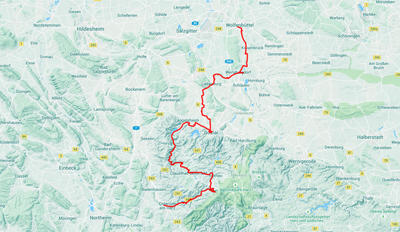 |
The last part crosses the Harz and reaches the highest point close to Clausthal-Zellerfeld, an old mining town. From there, you follow mostly old railroad tracks down to Goslar, an important medieval city with a beautiful city center. The endpoint of the journey is Wolfenbüttel with its famous library. From here, a good train connection exists to Braunschweig, where you can reach long-distance trains as well. Distance: 115 km - Uphill: 873 m - Downhill: 1041 m Download GPS track - open Google map |
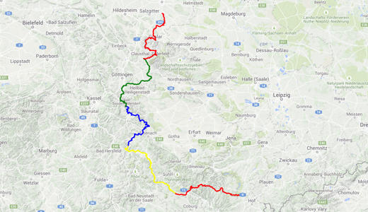
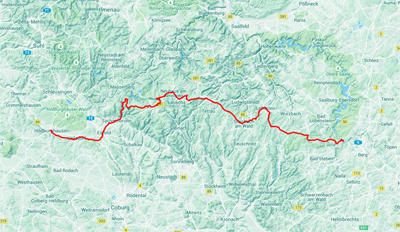
Saale River Bike Route and Thüringer Städtekette
This bike route starts at the spring of the Saale river and follows it to Jena, where it leaves the Saale and turns into the so-called Thüringer Städtekette (thuringian chain of cities). continuing to Weimar, Erfurt and Gotha. The Saale river route has quite exhausting and steep parts uphill and is recommended only for the better-trained bikers.
overall distance: 331 km - overall uphill: 3742 m - overall downhill: 3952 m
|
|
|
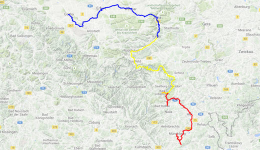
Part 1: Münchberg - Saale Spring - Hof - Bleilochstausee - Bad Lobenstein |
|
 |
From Münchberg, the route first goes straight up to the spring of the Saale river and then follows the official Saale river bike route. Between Rudolphstein and Blankenstein, we chose the route via Pottiga. Alternatively, one can also use the alternative via Eisenbühl. The route as provided here also contains a short detour into the Höllental starting from and going back to Blankenstein.. Distance: 100 km - Uphill: 1498 m - Downhill: 1535 m Download GPS track - open Google map - height profile |
Part 2: Bad Lobenstein - Bleilochstausee - Hohenwartestausee - Saalfeld - Kahla |
|
 |
Very beautiful, but exhausting. You can spend time at the two artificial lakes which you pass. Distance: 120 km - Uphill: 1533 m - Downhill: 1858 m Download GPS track - open Google map - height profile |
Part 3: Kahla - Jena - Weimar - Erfurt - Gotha |
|
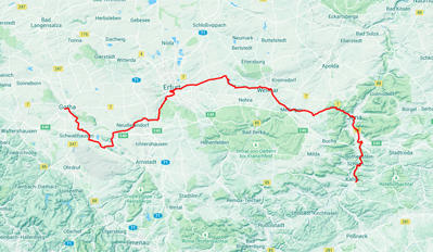 |
Visit the nicely renovated old German cities of Jena (optics industry), Weimar (the city of Goethe, Schiller and the first Bauhaus), Erfurt (the capital of Thüringen) and Gotha (where the first insurance company was founded). Time permitting, you can continue along the Thüringer Städtekette to Lutherstadt Eisenach. Distance: 111 km - Uphill: 711 m - Downhill: 559 m Download GPS track - open Google map - height profile |
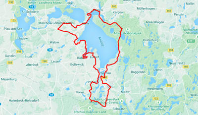
Mecklenburgian Lakes
Find three round trips around lakes in the Müritz region in Mecklenburg-Vorpommern. All three tours start in Göhren-Lebbin. To get there from Berlin, one can take the local train to Waren/Müritz.
overall distance: 250 km - overall uphill: 1226 m - overall downhill: 1241 m
|
|
|
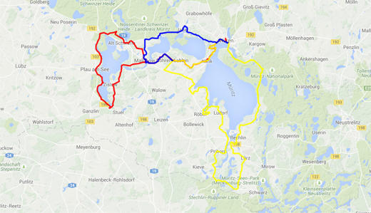
Part 1: Around Plauer See |
|
 |
Some parts of this route use unpaved paths through the woods. Mountain bikes are useful; racing bikes will have difficulties. Distance: 87.7 km - Uphill: 612 m - Downhill: 526 m Download GPS track - open Google map |
Part 2: Around Müritz and Müritzarm |
|
 |
Well paved roads that lead you quite far away from the banks of Müritz lake, with several points where you come close to the lake. Distance: 126 km - Uphill: 463 m - Downhill: 428 m Download GPS track - open Google map |
Part 3: Around Fleesensee and Kölpinsee |
|
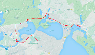 |
Some nice views on the lakes. The tour mostly uses paved and silent roads. As the part between Malchow and Alt Schwerin is not in good shape, a detour on a bike lane along a more frequented road was used. Distance: 36.2 km - Uphill: 151 m - Downhill: 187 m Download GPS track - open Google map |
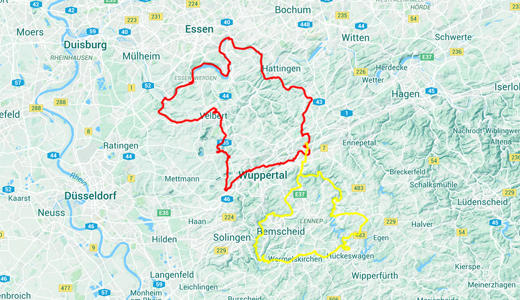
Along Old Railroad Tracks around Wuppertal
The two round trips follow at least in part old railroad tracks. The slopes are therefore not too steep and these tracks are well paved.
overall distance: 289 km - overall uphill: 1677 m - overall downhill: 1670 m
|
|
|
Part 1: Wuppertal - Radevormwald - Wermelskirchen - Wuppertal |
|
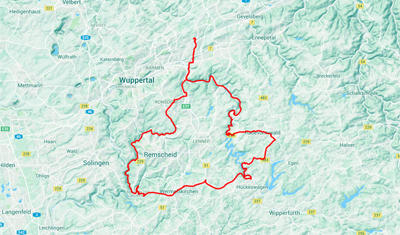 |
The tour goes from Wuppertal-Oberbarmen to the Wuppertalsperre, to Radevormwald, Hückeswagen and Wermelskirchen and back to Wuppertal. Inbetween old railroad tracks can be used to manage a large fraction of the up- and downhill slopes. Distance: 85.6 km - Uphill: 960 m - Downhill: 960 m Download GPS track - open Google map |
Part 2: Wuppertal - Hattingen - Essen - Velbert - Wuppertal |
|
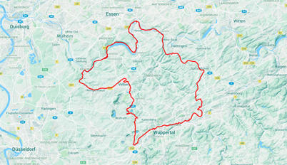 |
Follow an old railroad track from Wuppertal to Hattingen, where you meet the Ruhr river. The Ruhr bike route leads along Baldeney lake to Essen-Kettwig, where you switch to another old railroad track that leads you to Velbert. From there, you can return to Wuppertal and between Wuppertal-Vohwinkel and Wuppertal Nächstebreck, another railroad track exists (although not yet complete) which brings you back to the starting point. Distance: 103 km - Uphill: 707 m - Downhill: 700 m Download GPS track - open Google map |