
Longer Bike Trips (90 - 150 km)
Quicklinks
Shorter Routes (40 - 90 km) - Long-Distance Routes (several days)
The following bike trips have been recoreded with a Garmin Edge 800 bike navigator. They are available as GPS tracks in *.gpx format which can be read by most GPS devices. You can also use the maps created with Google Maps on GPS Visualizer, a very confortable tool to create maps from GPS tracks in different formats. Most tracks are located in or around Berlin. Almost all the bike trips described here are suitable for trekking bikes. At least parts of them may however include unpaved roads and therefore might be somewhat difficult for racing bikes.
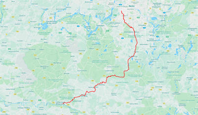
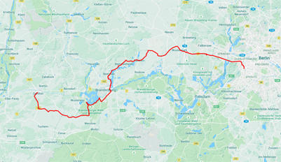
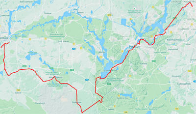
From Berlin to Wittenberg on the Berlin-Leipzig Bike Route
Distance: 135.0 km - Uphill: 324 m - Downhill: 318 m
Download GPS track - open Google map
|
|
The Berlin-Leipzig bike route leaves Berlin at the Berliner Mauerweg.in the South East of Berlin. Mostly rather silent streets take you to the "Fläming Skate" with its perfectly paved bike and skate lanes. From there, Wittenberg is reached as the first bigger town on the way to Leipzig. |
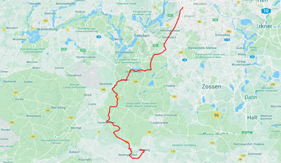
From Wittenberg to Berlin on the R1 Bike Route
Distance: 124.0 km - Uphill: 637 m - Downhill: 643 m
Download GPS track - open Google map
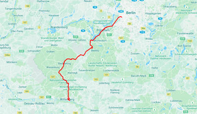 |
For those, who wish to return to Berlin by bike, the long distance bike route R1 offers the opportunity to use a different way than the Berlin-Leipzig route. Within the state of Sachsen-Anhalt, mostly unpaved, but well-prepared paths are used. The quality even improves once you enter the state of Brandenburg. Good train connections between Berlin and Wittenberg also allow using each one of the two routes independently. |
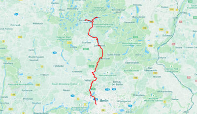
From Berlin to Eberswalde via Oranienburg
Distance: 98.3 km - Uphill: 322 m - Downhill: 298 m
Download GPS track - open Google map
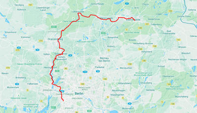 |
First, one follows the Berlin-Kopenhagen bike route to Hennigsdorf, then to Oranienburg. From there a very well-sustained bike lane along the Oder-Havel canal. The way along the old Finow canal takes you to Eberswalde. |
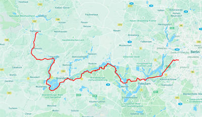
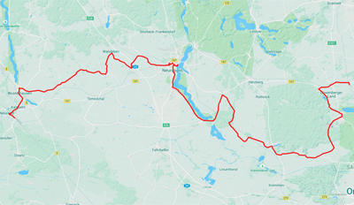
From Berlin to Rathenow on the Havelland Bike Route
Distance: 103.0 km - Uphill: 329 m - Downhill: 304 m
Download GPS track - open Google map
 |
There are two different long distance bike routes. This one is the "Havelland-Radweg", which does not closely follow the Havel river, but rather connects small villages and towns somewhat aside. Among them is Nauen, the city which became well-known because of its early twentieth century radio stations connecting the emperor's Germany with its colonies. Also you pass Ribbeck, which became famous for its pear tree through a poem by Theodor Fontane. |
From Rathenow to Berlin on the Havel Bike Route
Distance: 131.0 km - Uphill: 361 m - Downhill: 322 m
Download GPS track - open Google map
 |
Again, the way back to Berlin can be done on a different route. Now it's the "Havel-Radweg", which closely follows the Havel river through Brandenburg and Potsdam and is thus somewhat longer. |
From Berlin to Genthin via Wustermark and Brandenburg/Havel
Distance: 120.0 km - Uphill: 394 m - Downhill: 437 m
Download GPS track - open Google map
 |
This track does not follow any of the official bike routes, but provides mostly well-paved, not too busy roads. There are a few exceptions close to and in Brandenburg/Havel. After Karow, the direct state street to Genthin is recommended as the detour taken here leads through rather sandy and heavily damaged agricultural paths. |
From Erkner to Lübben on the Spreeradweg
Distance: 146.0 km - Uphill: 340 m - Downhill: 265 m
Download GPS track - open Google map
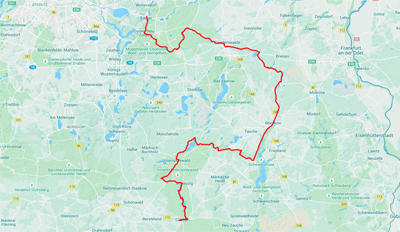 |
Erkner is easy to get to by S-Bahn from Ostkreuz. From there, follow the Spree bike route. Signs lead the way, but sometimes are not easy to detect. You will get to the Spreewald, a protected bioreserve, which nevertheless has many opportunities for tourists. Famous are the cucumbers and the gondolas which are used on the many water ways and channels. |
From Berlin via Königs-Wusterhausen and Erkner to Strausberg
Distance: 107.0 km - Uphill: 330 m - Downhill: 271 m
Download GPS track - open Google map
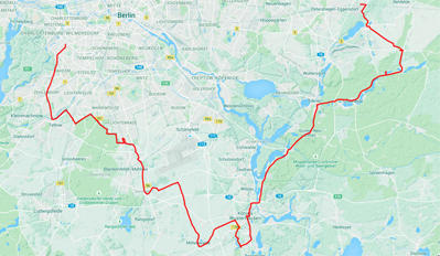 |
This tour starts in Berlin-Wilmersdorf, turns on the Berliner Mauerweg in Teltow, then follows a part of the Berlin-Leipzig bike route and finally connects different lakes close toKönigs-Wusterhausen, Erkner and Strausberg. Strausberg is connected through public transportation (S-Bahn) with Berlin city center. |
From Neuruppin via Oranienburg and Hennigsdorf to Berlin
Distance: 92.6 km - Uphill: 220 m - Downhill: 228 m
Download GPS track - open Google map
 |
The tour starts at the Neuruppin Rheinsberger Tor train station and follows mostly well-paved silent streets. Before you reach Oranienburg, the street is somewhat more busy. |
From Strausberg via Bad Freienwalde to Eberswalde
Distance: 104.0 km - Uphill: 710 m - Downhill: 727 m
Download GPS track - open Google map
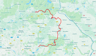 |
The tour starts from Strausberg S-Bahn station and leads through Buckow, a nice lake resort with many art nouveau houses. Then it goes through the Märkische Schweiz to Bad Freienwalde and brings you on silent streets through the Oderbruch to Eberswalde. |
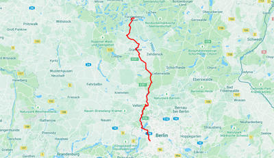
From Fürstenberg via Lychen, Zehdenick and Oranienburg to Berlin
Distance: 145.0 km - Uphill: 443 m - Downhill: 471 m
Download GPS track - open Google map
 |
The tour follows the Berlin - Copenhague bike route with a detour to Lychen, a small town between three lakes, throught Himmelpfort, Zehdenick, Oranienburg and ends in Berlin. |
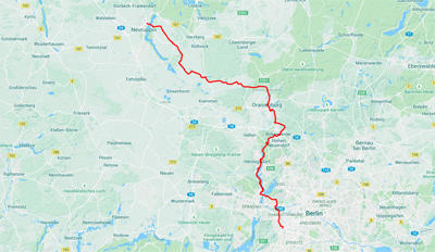
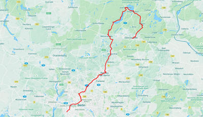
From Berlin via Oranienburg, Gransee to Fürstenberg
Distance: 115.0 km - Uphill: 348 m - Downhill: 333 m
Download GPS track - open Google map
 |
Within Berlin, the tour follows the Berlin - Copenhague bike route, but leaves it in Oranienburg to explore a different route to Fürstenberg through the Löwenberger Land, Liebenberg, and Gransee. Most of the streets are silent and well paved. Along most of the more frequented streets, bike lanes exist. |
From Berlin via Bernau and Joachimsthal to Eberswalde
Distance: 110.0 km - Uphill: 516 m - Downhill: 489 m
Download GPS track - open Google map
 |
After crossing the city of Berlin, the tour follows the Panketal north of Berlin to Bernau. It uses mostly the Berlin-Usedom long-distance bike route to Joachimsthal and then turns south from there to Eberswalde. |
From Brandenburg via Kloster Lehnin and the Schwielowsee to Berlin
Distance: 101 km - Uphill: 360 m - Downhill: 336 m
Download GPS track - open Google map
 |
This is another alternative to go from Brandenburg to Berlin south of the Havel river and Havelland bike routes described above. At the south end of Schwielowsee, this route meets the Schwielowsee-Caputh round trip described among the shorter trips. |
From Jüterbog via Treuenbrietzen and Beelitz to Berlin
Distance: 103 km - Uphill: 251 m - Downhill: 244 m
Download GPS track - open Google map
 |
Jüterbog is easy to reach from Berlin by local trains that frequently run between Berlin-Südkreuz and Wittenberg. The tour touches "aspargus city" Beelitz. |
From Löwenberg via Neuruppin to Neustadt/Dosse
Distance: 96.6 km - Uphill: 138 m - Downhill: 142 m
Download GPS track - open Google map
 |
A tour through the countryside and along Neuruppiner See. Both, Löwenberg and Neustadt/Dosse are served by local trains. |